


Roseville Twp. Voting District, Kandiyohi County, Minnesota
About
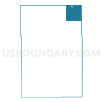
Outline

Summary
| Unique Area Identifier | 602712 |
| Name | Roseville Twp. Voting District |
| County | Kandiyohi County |
| State | Minnesota |
| Area (square miles) | 35.41 |
| Land Area (square miles) | 34.97 |
| Water Area (square miles) | 0.44 |
| % of Land Area | 98.75 |
| % of Water Area | 1.25 |
| Latitude of the Internal Point | 45.36624650 |
| Longtitude of the Internal Point | -94.81941460 |
Maps

Graphs
Select a template below for downloading or customizing gragh for Roseville Twp. Voting District, Kandiyohi County, Minnesota


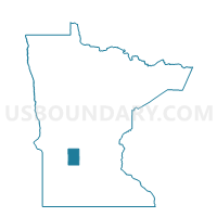
Neighbors
Neighoring Voting District (by Name) Neighboring Voting District on the Map
- Burbank Twp. Voting District, Kandiyohi County, MN
- Crow River Twp. Voting District, Stearns County, MN
- Irving Twp. Voting District, Kandiyohi County, MN
- Lake Henry Twp. Voting District, Stearns County, MN
- New London Twp. Voting District, Kandiyohi County, MN
- Paynesville Twp. Voting District, Stearns County, MN
- Regal Voting District, Kandiyohi County, MN
- Union Grove Twp. Voting District, Meeker County, MN
- Zion Twp. P-2, Stearns County, MN
Top 10 Neighboring County Subdivision (by Population) Neighboring County Subdivision on the Map
- New London township, Kandiyohi County, MN (2,943)
- Paynesville township, Stearns County, MN (1,421)
- Irving township, Kandiyohi County, MN (906)
- Union Grove township, Meeker County, MN (633)
- Roseville township, Kandiyohi County, MN (622)
- Burbank township, Kandiyohi County, MN (566)
- Zion township, Stearns County, MN (335)
- Crow River township, Stearns County, MN (327)
- Lake Henry township, Stearns County, MN (278)
- Regal city, Kandiyohi County, MN (34)
Top 10 Neighboring Place (by Population) Neighboring Place on the Map
Top 10 Neighboring Unified School District (by Population) Neighboring Unified School District on the Map
- New London-Spicer School District, MN (9,166)
- Paynesville Public School District, MN (6,164)
- Belgrade-Brooten-Elrosa School District, MN (4,290)
Top 10 Neighboring State Legislative District Lower Chamber (by Population) Neighboring State Legislative District Lower Chamber on the Map
- State House District 14B, MN (40,101)
- State House District 13A, MN (38,763)
- State House District 18B, MN (37,973)
- State House District 13B, MN (37,827)
Top 10 Neighboring State Legislative District Upper Chamber (by Population) Neighboring State Legislative District Upper Chamber on the Map
- State Senate District 14, MN (86,315)
- State Senate District 13, MN (76,590)
- State Senate District 18, MN (76,242)
Top 10 Neighboring 111th Congressional District (by Population) Neighboring 111th Congressional District on the Map
Top 10 Neighboring Census Tract (by Population) Neighboring Census Tract on the Map
- Census Tract 7803, Kandiyohi County, MN (4,189)
- Census Tract 110, Stearns County, MN (3,901)
- Census Tract 109, Stearns County, MN (3,821)
- Census Tract 5606, Meeker County, MN (2,941)
- Census Tract 7801, Kandiyohi County, MN (2,581)